Generated Monday September 28, 2026 06:00 AM Pacific
Spray Creek Ranch (Lillooet)
Notes from Julia · wed 12 aug, 12:59pm (46.7 days ago)
· no new note since the last briefing· HISTORIC, not current
Looking pretty good here this morning. We had a briefing early yesterday afternoon with the Incident Commander, Structure Protection and the new Australian Community Communications person, to discuss next steps with the fire encroaching on the range in the Texas Creek basin. We're supposed to be taking the cattle up there next week, so we're obviously pretty concerned about access. It doesn't sound like they're going to do much, as they don't feel they can get crews in there safely. It would have been nice to have this communications person a couple of weeks ago, but hopefully now she can take some of the burden off Tristan, who has been spending many hours of incredibly valuable time sourcing, ground-truthing and disseminating much-needed information to the wider community.
After the briefing we headed up to complete repairs on the flume. We found our work area easily, as it was clearly marked with yellow flagging tape that said "No Work Zone." Tristan carried on with the braces while I cleared the endless supply of fuels from under the flume, then whittled little cedar sticks to jam into the gaps in the new section — which was actually quite relaxing. Or it would have been, if there hadn't been a loud-ass pump droning away the whole time. We got the flume running again at 6:05pm. Very satisfying, considering that only three days ago it looked like the whole thing was going to burn.
Early dinner at 7:30 (yes, we had pizza again, but we ALSO had a box of freezer chicken fettuccine alfredo), with lightning alerts popping up on my phone and the wind picking up. We were feeling relatively good, though, since we knew the whole area from Spray Creek to Cat Creek was pretty much finished burning and under control. For the first time in a long while we didn't have to go out and deal with any emergencies, and we got to sleep at a reasonable hour for a change.
This morning I went out to take a peek up Texas Creek and was happy to see everything looking very mellow. At the morning briefing we learned that the burn is indeed finished, with no spots within 25 feet of the control line the whole way from Cat Creek to Spray Creek. It sounds like we'll have full crews on 24 hours for at least two more days, and they expect to have a drone scanning tonight.
After that we went up in the helicopter to assess the range, so we can make some decisions about taking the cows up next week. It seems highly unlikely the fire will make it that far back any time soon, if at all — access is the real issue, since to get in or out we need to travel the Texas Creek FSR. It was great to see the range from the air; it'll help me orient myself on the ground in future. It sure is beautiful up there, saw a cool bear den, and we got out of the smoke for the first time in ages.
On the weather: today is warm and breezy — around 27°C, humidity down near 35%, and northwest gusts up to 40 km/h through the afternoon. That's the wind shift we'd been watching all week, but it's arriving with the burn already down to the line here, which is very much the order you'd want those two things to happen in. Thursday and Friday look similar and a little calmer.
The weekend is the part worth keeping an eye on. Saturday through Monday warm up to 30–31°C with humidity dropping to somewhere around 18–25%, and no rain in the forecast. That's the first stretch in a while where the humidity is expected to fall below the temperature, which is the combination that can wake up interior pockets in a fire that's otherwise lying down. There are also a few hours of possible dry lightning over the next two days — which is what those alerts on my phone were about.
Riley Creek is now listed at 2,600 hectares. We expect the order to be lifted tonight, so unless anything changes here, this will probably be my last briefing update.
I may have to shift my attention to the Ainslie Creek fire now, which is still growing and moving towards my property, where we remain on alert. It's now at 61,399 hectares — it added close to 13,000 hectares in the last day alone. The alert was expanded yesterday to include the south side of the Coquihalla, as there's significant activity on that fire's southern leading edge. I'll drop a screenshot of that fire on my map below; the yellow house icon is my place. It's still a ways away — we're about 4 km from the evacuation order boundary. All the livestock are gone, and what little else I care about is packed and ready to go.
Time to regroup and get a handle on everything I've been ignoring for the past three weeks. Apparently the rest of the province is on fire too, and I have a lot of office work to catch up on. Thanks to all of you who have been checking in — it was nice to know you were all cheering for us. :)
Older than 18 h — fire behaviour turns over on an
afternoon-to-afternoon cycle, so read this as context, not as the situation now.
Also burning nearby: 258 (K71668, Twin Two Creek, K71651, V11496, Tuwasus Creek, V31722, ...)
Satellite hotspot detections (24h, FIRMS): 0
No satellite detection in the last 12 h — this means no overpass, not that fires are inactive.
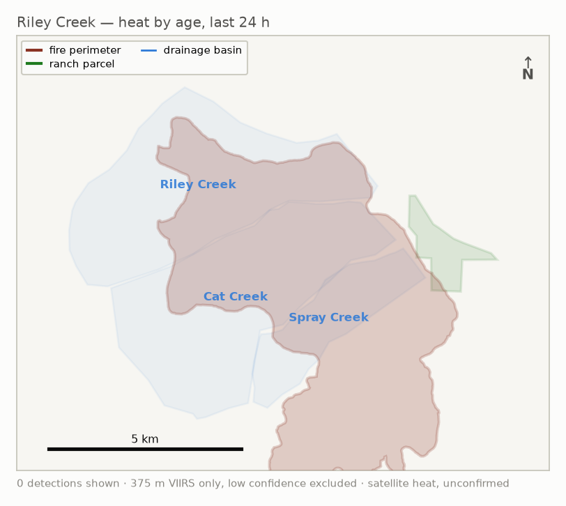
Where the heat is
Flat overhead view. It cannot show whether the fire is above you or across a
drainage — for that, open the 3D map linked in the table above and tilt the view.
Both maps show 375 m VIIRS detections only. To include coarse 1 km MODIS and
FIRMS-flagged low-confidence pixels, open
all-detections.kmz
— a separate file, because Google Earth on mobile ignores layer visibility
and cannot switch them off once loaded.
This is a convenience/summary layer, not the authoritative source. An "all clear" here never substitutes
for official information. Evacuation order/alert status is tracked by you directly, not by this system.
About the satellite data
Hotspots come from NASA FIRMS. They are detections of heat, not confirmations of
fire — a red dot is a satellite's best guess from orbit, and it can be wrong
or misleading.
This briefing uses only the most reliable of what FIRMS publishes: 375 m VIIRS
pixels, with low-confidence detections and coarser 1 km MODIS pixels switched off
by default. That is a deliberate choice for accuracy, and it still is not perfect.
Detections can land on hot rock, equipment, or a metal roof; a single pixel covers an
area far larger than a dot on a map suggests; and position can be off by hundreds of
metres.
Just as important is what an absence of dots means. Satellites pass overhead only
a handful of times a day, so gaps of 9–13 hours are normal, and a fire that is
burning hard will show nothing at all until the next pass — plus roughly
3 hours of processing before it reaches us. Smoke also suppresses the signal, so the
most active fires can read cooler than they are.
Treat this as one input among several, never as the answer. Where the ground and
the satellite disagree, the ground wins. Verify with
BC Wildfire
before acting on anything here.